Dual network tracking continuity
Dual network tracking continuity.
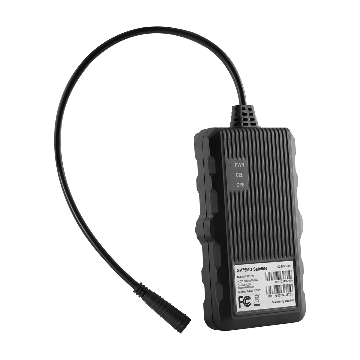

LTE Cat M1/GSM & NTN Satellite Tracker
The GV75MG SAT is a vehicle and asset tracking device designed for operations that move across wide areas. An IP67-rated enclosure allows it to withstand water, dust, and harsh outdoor conditions.
Dispatch and lead time are confirmed in the quote.

Manufacturer warranty24 months
Overview
The GV75MG SAT is a vehicle and asset tracking device designed for operations that move across wide areas, including regions with limited cellular coverage. It combines cellular and satellite communication to keep assets visible even when traditional networks are unavailable. This makes it suitable for long-distance transport, remote routes, and maritime-related operations.
The device supports both LTE Cat M1/GSM and NTN satellite communication, allowing it to continue reporting when cellular service is lost. This dual-path connectivity helps maintain tracking continuity in remote or offshore environments. Scheduled and event-based reporting ensures location and status updates are sent at the right time without constant manual checks.
An integrated multi-constellation GNSS receiver enables accurate and consistent positioning in different environments. Support for GPS, BDS, Galileo, and GLONASS improves reliability when signals are weak or obstructed. This helps operators maintain confidence in location data across cities, highways, and open areas.
The GV75MG SAT monitors a wide range of vehicle and asset events, including motion, towing, speeding, and ignition status. Built-in crash detection and driving behavior monitoring provide useful data for safety analysis and incident review. Jamming detection adds another layer of awareness by alerting when signal interference is suspected.
The device operates on a wide DC 9–90V input, making it compatible with different vehicle types and power systems. An IP67-rated enclosure allows it to withstand water, dust, and harsh outdoor conditions. A backup battery keeps the tracker running and reporting during temporary power loss.
BLE 5.2 support allows the device to work as a gateway for nearby accessories such as beacons and sensors. Configurable inputs and outputs enable basic integration with vehicle signals or external equipment. This flexibility helps adapt the tracker to different operational setups without complex hardware changes.
Dual network tracking continuity.
Event-based status reporting.
Vehicle behavior monitoring.
Accident and tow detection.
Remote device management.
LTE Cat M1 and satellite support.
IP67 waterproof enclosure.
9–90V wide voltage input.
Technical data
| General Specifications | |
|---|---|
| Dimensions | 112(L) × 65(W) × 20(H) mm |
| Weight | 160 g |
| Backup Battery | Li-Polymer, 1100 mAh, Rechargeable |
| Standby Time | Without reporting: 2630 hours 5 min reporting: 39 hours 10 min reporting: 126 hours |
| Operating Voltage | 9 ~ 90 V DC |
| Zero Power Consumption | Vehicle battery drain prevention when ignition is off, typ. <0.4 mA @12V |
| Waterproof | IP67 compliant |
| Operating Temperature | −20 °C to +70 °C |
| Storage Temperature | −30 °C to +80 °C |
| BLE | Support BLE 5.2 protocol |
| Region | Global, North America |
| GNSS Specifications | |
| GNSS Type | All-in-one GNSS receiver, A-GPS supported |
| Constellation Support | GPS, BDS, Galileo, GLONASS |
| Sensitivity | Cold start: −149 dBm Hot start: −165 dBm Tracking: −159 dBm |
| Position Accuracy (CEP) | Autonomous < 2.0 m |
| TTFF (Open Sky) | Cold start: 26 s average Hot start: 1 s average |
| LTE Specifications | |
| Operating Band | LTE-FDD Cat M1: B1, B2, B3, B4, B5, B8, B12, B13, B18, B19, B20, B25, B26, B27, B28, B66, B85; LTE Cat NB2: B1, B2, B3, B4, B5, B8, B12, B13, B18, B19, B20, B25, B28, B66, B71, B85 |
| Data Transmission | Cat M1: Max 588 kbps DL / 1119 kbps UL Cat NB2: Max 127 kbps DL / 158.5 kbps UL Cat NB1: Max 32 kbps DL / 70 kbps UL |
| GSM / GPRS / EDGE Specifications | |
| Frequency | 850 / 900 / 1800 / 1900 MHz |
| Data Transmission | EDGE: Max 296 kbps DL / 236.8 kbps UL GPRS: Max 107 kbps DL / 85.6 kbps UL |
| IoT-NTN Specifications | |
| Operating Band | B23 / B255 / B256 |
| Sensitivity | B23: −115 / −108.2 dBm B255: −115 / −108.2 dBm B256: −115 / −108.2 dBm |
| Interfaces | |
| Digital Input | 1 × positive trigger input for ignition detection |
| Configurable Input / Output | 2 × configurable I/O Digital input: active low Digital output: open drain, 150 mA max |
| Serial Port | 1 × RS232 serial port for debugging |
| Cellular Antenna | Internal only |
| GNSS Antenna | Internal only |
| BLE Antenna | Internal only |
| LED Indicators | PWR, CEL, GPS |
| Air Interface Protocol | |
| Transmission Protocol | TCP, UDP, SMS |
| Scheduled Report | Report based on time, distance, mileage, or combination |
| Geo-fences | Geo-fence & parking alarm, up to 20 regions |
| Speed Alarm | Flexible speed monitoring |
| Low Power Alarm | Alarm when backup battery is low |
| Power On Report | Report when device is powered on |
| SOS Alarm | Panic button emergency alarm |
| Tow Alarm | Tow alarm in ignition-off state |
| Jamming Detection | Jamming detection alarm |
| Virtual Ignition Detection | Based on voltage and accelerometer |
| Driving Behavior Monitoring | Harsh braking, acceleration, etc |
| Crash Detection | Accident data collection and analysis |
| Motion Detection | Internal 3-axis accelerometer |
| Remote Control | OTA control of digital outputs |
| Connectivity | |
| Technology | BLE |
| Frequency | 2.4 GHz |
| Remark | BLE 5.2, works as BLE gateway for beacons and sensors |
No specification rows match the filter.
Applications
The device supports fleet operators by providing continuous tracking, driving behavior monitoring, and incident detection across long routes. Dual cellular and satellite communication helps maintain visibility even in remote areas.
For freight and asset movement, the tracker enables location monitoring, geo-fence alerts, and tow detection. This helps reduce loss, improve delivery transparency, and support route compliance.
Satellite connectivity allows positioning and status reporting for ocean-going vessels where cellular networks are unavailable. The waterproof design supports long-term operation in marine environments.
The tracker can be used on mobile machinery to monitor movement, unauthorised towing, and usage patterns. BLE support allows connection to additional sensors for expanded visibility on job sites.
Features such as jamming detection, motion alerts, and geo-fences support theft prevention and asset recovery efforts. Event-based alarms help operators respond quickly to abnormal activity.
Documentation
Accessories
Optional hardware specified for this model.
 Queclink
IButton Kit without
 Queclink
CANBus and J1708 Adapter
 Queclink
I/O Expander
 Queclink
DS18B20 1-Wire Digital Temperature Sensor
 Queclink
BLE external tire pressure monitoring sensor
 Queclink
BLE internal tire pressure monitoring sensor
 Queclink
Capacitive Fuel Sensor(BLE)
 Queclink
LEO TAG FOR CATTLE TRACKING
 Queclink
Ultrasonic Fuel Sensor
 Queclink
BLE Beacon
 Queclink
BLE Beacon with NFC configuration and 3-axis accelerometer
 Queclink
BLE 5.2 beacon for tool and asset tracking
 Queclink
BLE Key Fob
 Queclink
BLE door sensor with temperature and humidity monitoring func...
 Queclink
Redundant BLE Sensor with RF433 Support for Enhanced Stolen V...
 Queclink
BLE Relay
 Queclink
BLE Temperature and Humidity Sensor
Questions
–20 … +70 °C, according to the specification.
IP67, according to the specification.
Dual network tracking continuity, according to the manufacturer description.
All-in-one GNSS receiver, A-GPS supported, according to the specification.
Request a quote
Tell us the quantity and the delivery country. We reply within one working day with the price, stock at the nearest warehouse and the dispatch date.
Manufacturer warranty24 months
Europe & United Kingdom
Product advice, availability and project enquiries.
All contact details


