Cattle location tracking
Cattle location tracking.
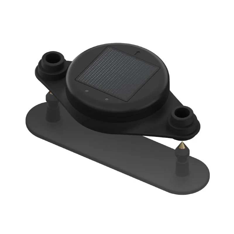

Leo tag for cattle tracking
The GLS10 is an Leo tag for cattle tracking. It also supports real-time location viewing and history location records, so ranchers can check both current position and past movement.
Dispatch and lead time are confirmed in the quote.

Manufacturer warranty24 months
Overview
The GLS10 is built for cattle tracking and herd visibility across wide grazing areas. It helps ranchers see where animals are located without needing land-based infrastructure. This makes it useful for large or remote pastures where regular manual checking takes time.
This device uses LEO satellite communication, which is intended to support tracking on a global scale. In practice, that means location data can still be sent from areas where traditional local infrastructure may be limited. The reporting schedule is also controlled, with up to 4 reports per day based on the settings used.
The GLS10 uses L1 GNSS for location tracking. Its stated position accuracy is above 5 metres, which supports general visibility of animal location in the field. It also supports real-time location viewing and history location records, so ranchers can check both current position and past movement.
The device includes virtual fence and danger zone functions. These allow alerts when animals move outside a set pasture boundary or get close to an area that should be avoided. It also supports animal death alerts and low battery detection, helping users react faster when attention is needed.
The GLS10 uses solar charging, with a maximum charging value of 30 mA. It has a standby time of 14 days without charging, which helps support field use when sunlight is limited for a period. With an IP67 rating and an operating range of -20 °C to +60 °C, it is designed for outdoor livestock environments.
Cattle location tracking.
Virtual fence alerts.
Danger zone alerts.
Adjustable report scheduling.
Movement history viewing.
Low battery alerts.
96 × 53 × 18 mm size.
42 g device weight.
Technical data
| Telematics | |
|---|---|
| Telematics | LEO (Low Earth Orbit) |
| Region | Global |
| GNSS | |
| GNSS | L1 |
| Location frequency | 4 reports per day |
| Position accuracy | >5m |
| Power | |
| Standby Time | 14 days (without charging) |
| Battery Charging | Solar panel (Max: 30mA) |
| Environmental | |
| Operating Temperature | -20℃ ~ +60℃ |
| Waterproof | IP67 Compliant |
| Physical | |
| Dimensions | 96x53x18mm |
| Weight | 42g |
No specification rows match the filter.
Applications
This device fits cattle ranching by giving location visibility across open grazing land. Virtual fence alerts and movement history help ranchers monitor animals more easily and respond when livestock leave the expected area.
For pasture control, the GLS10 helps confirm whether animals remain within assigned grazing zones. Danger zone settings also support better control around restricted or sensitive areas.
The device supports livestock security by alerting users when animals move outside fenced zones. The datasheet also notes its value during herd searching periods, helping ranchers locate animals more efficiently.
In remote farming environments, the GLS10 is useful because it works without land infrastructure and uses LEO communication for wide-area coverage. Solar charging and outdoor protection also make it more practical for long-term field deployment.
Documentation
Compatible products
Equipment this accessory is specified to work with.
 Queclink
LTE Ruggedized Waterproof Solar Powered Asset Tracker
 Queclink
GNSS Telematics Tracker
 Queclink
2G vehicle tracker with built-in BLE 5.4, built for fleet mon...
 Queclink
GNSS Telematics Tracker
 Queclink
LTE Cat 1bis vehicle tracker with 2G fallback, built for flee...
 Queclink
LTE Cat M1/GSM & NTN Satellite Tracker
Questions
IP67, according to the specification.
–20 … +60 °C, according to the specification.
IP67, according to the specification.
Request a quote
Tell us the quantity and the delivery country. We reply within one working day with the price, stock at the nearest warehouse and the dispatch date.
Manufacturer warranty24 months
Europe & United Kingdom
Product advice, availability and project enquiries.
All contact details


